Old Hickory Lake Waterproof Map #1730
$13.99 – $34.99


Old Hickory Lake Waterproof Map #1730
$13.99 – $34.99
23″x35″ Two-sided. Scale 1:35,036
Waterproof and Tear Resistant!
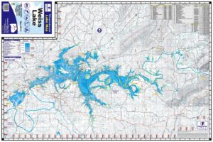
Old Hickory Lake 23″x35″ Two-sided. Scale 1:35,036 Waterproof and Tear Resistant! Old Hickory Lake was constructed by the U.S. Army Corps of Engineers beginning January, 1952. The dam was closed and the filling of the lake began June 11, 1954. The lock opened to navigation June 14, 1954 and electrical power began production April 5, 1957. The total cost of the project was $48,681,700. The elevation of the reservoir at maximum pool level, which covers an area of 22,500 acres, is 445 feet above sea level. The normal minimum pool, which covers an area of 19,550 acres, is 442 feet above sea level. The backwater length of the reservoir at the top of the gate level (mainstream) is 97.3 miles long. Old Hickory Reservoir at maximum pool has 440 miles of shoreline and contains 467,000 acre feet of water. The water shed area (the area of land from which the water feeds the lake) covers 11,674 square miles. Old Hickory Dam is located on the Cumberland River at mile 216.2, and is in Davidson and Sumner Counties, Tennessee, 25.5 miles upriver from Nashville. The counties surrounding Old Hickory Lake include Davidson, Sumner, Wilson, Trousdale, and Smith Counties.
Additional information
| Weight | N/A |
|---|