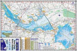
Lake Murray Waterproof Map #311
Price range: $13.99 through $34.99


Lake Murray Waterproof Map #311
Price range: $13.99 through $34.99
- Waterproof & Tear Resistant Map
- One-sided 24″x36″
- Lake Structure, Navigational Markers and Road Network
- Marinas, Boat Ramps and Facilities
- Full Color
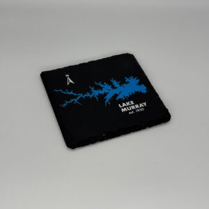
Lake Murray, South Carolina One-sided 24″x36″ Waterproof & Tear Resistant Map
Lake Murray was formed by the construction of the Saluda Dam on the Saluda River at Dreher Shoals by South Carolina Electric and Gas Company(SCE&G). Construction began in 1927 and reached completion in 1930, using approximately 11 million cubic yards of earth carried by train to the dam site.
Lake Murray offers much in the way of recreation, having many marinas and public use areas scattered around the 525 mile shoreline. Along with camping, sailing, boating, waterskiiing and fishing, Lake Murray’s 50,000 acres of clear water surely offer the water-sports-minded the best central South Carolina has to offer! The fishing can be exciting at almost any time of the year, since this lake has a thriving population of many species of game fish, including Largemouth Bass, Smallmouth Bass, White Bass, Striped Bass(Rockfish), Crappie, Yellow Perch, and Bream.
Additional information
| Weight | 5 oz |
|---|---|
| Dimensions | N/A |